-
首頁
-
new訂閱制數位訂閱制 Ivy Engrest 介紹 數位訂閱制 Ivy Engrest 新手攻略new數位訂閱制 優惠方案 註冊享免費體驗 7 天,再送 $200
-
看文章登入註冊公開精選文章
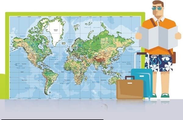
繞彎路比較近?飛機路線大揭密 The Shortest Distance between Two Points Is Not Necessarily a Straight Line!
兩點之間最短的距離是直線,對嗎?不見得!
#休閒旅遊
難度 收藏文章
地圖 上測量到的直線就不見得是最快的路徑了。怎麼會這樣呢?
>> 祕境溫泉攏系假 澳洲旅遊網站 AI 出包/在仿月壤成功種出鷹嘴豆 太空種植物不是夢

科普園地 4 分鐘閱讀
Bruce, Angela, Wesley
The shortest distance between two points is a straight line, right? Not necessarily! That depends on the scale of what we are talking about. True, the most direct path from one side of a room to the opposite side is a straight line. We can measure the span to prove this.
兩點之間最短的距離是直線,對嗎?不見得!要視我們正在談論的尺度而定。確實,要從房間的一邊到對面的話,最直接的路徑是直線。我們可以測量空間兩點的長度來證明這點。
- depend on / upon... 視……而定;依賴……
- scale [ skel ] n. 尺度,範圍,規模
However, when we use a much larger scope—a global scale, perhaps—a straight line as measured on a map is not necessarily the fastest way to move between two points. How can that be?
不過,當我們說的是更大的範圍 ── 或許是全球尺度 ── 那麼要在兩點之間移動,地圖上測量到的直線就不見得是最快的路徑了。怎麼會這樣呢?
- scope [ skop ] n. 範圍;空間;機會
Most maps are printed on flat pieces of paper. The most commonly used is called the Mercator projection, which projects the spherical world onto a flat, two-dimensional surface, exaggerating the size of the northern and southern polar areas.
大多數的地圖都印在平面的紙上。最常使用的方法是麥卡托投影法,這種方法是將球狀的世界投射到二維平面上,加大了南北極區域的大小。
- Mercator projection 麥卡托投影法(一種等角的圓柱形地圖投影法,在以此投影法繪製的地圖上,經緯線於任何位置皆垂直相交,使世界地圖可以繪製在一個長方形上)
- spherical [ ˈsfɛrəkl̩ / ˈskɪrəkl̩ ] a. 球形/體的
- dimensional [ dəˈmɛnʃənl̩ ] a. 空間維度的,次元的
- exaggerate [ ɪgˈzædʒəˌret ] vt. 誇大
Pull up a map. As you can clearly see, the island of Greenland—located up by the North Pole—is depicted as a huge landmass. As a matter of fact, it is merely two-thirds the size of India, which appears smaller as it lies much closer to the equator. This distortion of space on flat maps warps our impression of straight lines and of relative distances.
拿出一張地圖。正如你可以清楚見到的,格陵蘭島 ── 位於北極上方 ── 被描繪成一大塊土地。實際上,它僅有印度的三分之二大,而印度卻因為離赤道近得多而變得較小。在平面地圖上扭曲的空間曲解了我們對直線和相對距離的印象。
- be depicted as... 被描述成/形容為⋯⋯
- landmass [ ˈlændˌmæs ] n. 地塊,陸塊
- equator [ ɪˈkwetɚ ] n. 赤道
- warp [ wɔrp ] vt. 扭曲;使有偏見
As an example, suppose you want to journey from New York to Taipei. Using a typical Mercator projection map, you would assume that the best flight route would be by heading west via the continental US and over the Pacific Ocean.作為例證,假設你想要從紐約到臺北旅行。使用一個常規的麥卡托投影法地圖,你會猜想最佳的飛行路線是向西行,經由美洲大陸,再越過太平洋。
- journey [ ˈdʒɝnɪ ] vi. & n. 旅行(尤指長途旅行)
- route [ rut / raʊt ] n. 路線
- continental [ ˌkɑntəˈnɛnt ] a. 大陸的
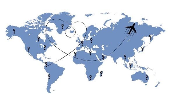
In reality, that itinerary would be a considerable waste of both time and money. To show why, prepare a piece of string and get hold of a globe. With one end affixed to New York and the other to Taipei, pull the strand taut. Surprise! Now, you’ll have to concede that the shortest distance is going north over Alaska and Russia, then southward towards Taipei.
實際上,那樣的行程會相當耗時又浪費錢。為了說明原因,準備一條線、再拿一個地球儀。一端固定在紐約,另一端固定在臺北,接著將線拉緊。想不到吧!現在,你必須承認最短的距離是往北越過阿拉斯加和俄羅斯,接著再向南飛往臺北。
- itinerary [ aɪˈtɪnəˌrɛrɪ ] n.(旅行的)行程,路線
- get hold of... 拿來/找來⋯⋯
- affix [ əˈfɪks ] vt. 附/貼上(常用被動)
- taut [ tɔt ] a. 拉緊的
接著閱讀
想要閱讀完整文章嗎?本篇文章取自《解析英語 109/06/03》,雜誌內有更多單字片語、例句與文法補充,立即到IVY書城帶回家看。↓ ↓ ↓ 看完文章收穫滿滿嗎?快分享給需要一起學好英文的他/她。轉爆這篇文章,給作者愛的鼓勵!(厚嘿。:.゚ヽ(*´∀`)ノ゚.:。)↓ ↓ ↓
>> 大海東去,浪淘盡,漂浮飯店成幻影The Hotel That Lived on the Reef
延伸閱讀
關鍵字: #休閒旅遊
本篇內容出自《常春藤解析/生活英語雜誌》,
2026/08/16 00:00 前買享優惠Ivy Engrest 訂戶在訂閱期間訂閱紙本(無贈品版本)再享最低 62折優惠!)>>
【雜誌訂閱】MORE&MORE
回饋與建議
為了提供更好的閱讀體驗與學習感受,有任何建議或問題歡迎留言讓我們知道,感謝~
英文問題僅回答您對本篇文章的疑慮(發現單字拼錯、文法有問題)等,其他延伸問題恕不提供回答服務。謝謝。學會了嗎?✋來答題得 熊贈點~
恭喜答對獲得 熊贈點 1點
答
題
賺
點
數作者

Bruce E. Bagnell
常春藤解析英語雜誌資深外籍教師,中英文流利,曾為台灣大學資深教授,與賴世雄老師為多年好友。